
Blackman Township ZIP Code Directory Coverage
Current research identifies three ZIP codes associated with Blackman Township: 49201, 49202, and 49203. None is a township-only ZIP. The useful question is not which ZIP belongs to Blackman. It is whether a complete delivery address validates to a postal area and whether its parcel is in Blackman Charter Township. The township borders the City of Jackson, and a Jackson mailing label does not establish city residency. County GIS and the township assessor provide the municipal check after a postal result.
| ZIP | Areas | Post Office | Notes |
|---|---|---|---|
| 49201 | Blackman Township addresses reported with a Jackson label | Jackson postal label | Postal area, not a township boundary. |
| 49202 | Blackman Township and nearby jurisdictions | Jackson postal label | Also reaches parts of nearby Leoni and other areas. |
| 49203 | Blackman Township addresses reported with a Jackson label | Jackson postal label | Validate the complete delivery address. |
Exact street-by-street ZIP splits were not captured in an official reproducible source. This postal reference should therefore not publish guessed street lists, geographic percentages, or a promise that every address in one code is in the township. Use the full address with USPS, then check the county parcel map. The statewide Michigan ZIP map is a visual reference only, not a tool for validating a particular delivery address.
Blackman Township ZIP Codes and Jackson Mail
“Jackson, MI” is a postal city label used by addresses in more than one local jurisdiction. It is not the same thing as the City of Jackson boundary. A parcel can carry a Jackson mailing label while county GIS identifies Blackman Charter Township as the municipality. The same address may also have a voter precinct and Census geography. Those are separate systems with separate purposes, so they should never be compressed into one assumed location.
Boundary check. A Blackman Township postal label or ZIP is only a search aid; confirm the parcel municipality before treating an address as township-based.
Jackson County GIS manages parcel, address, street-centerline, 911, aerial, and voting information. Use the Jackson County Parcel Viewer after postal validation. If the full-address result and parcel jurisdiction disagree, keep both results and ask the township or GIS office which record governs the question. This is especially important around Blackman’s border with the City of Jackson and other Jackson County townships.
Note: Postal delivery, parcel jurisdiction, and precinct geography should remain separate fields when recording a Blackman Township address.
Verify a Blackman Township ZIP Code
Use the USPS ZIP Code Lookup with the complete delivery address, not a town name alone. The research did not capture an official reproducible result for a sample address in every Blackman ZIP, which is why a live full-address check matters. Copy the house number, directional, street type, unit if any, city label, state, and returned ZIP exactly before moving to county records.
| Full delivery address | Use the complete address to obtain a current postal ZIP result. |
|---|---|
| Postal city and ZIP | Record the returned label as postal information, not municipal proof. |
| Parcel jurisdiction | Use county GIS to check Blackman Charter Township or another municipality. |
| Address authority | Ask Blackman zoning or county GIS when an existing address or map needs clarification. |
The captured USPS address-lookup screen is the official starting point for a Blackman Township postal-area search.
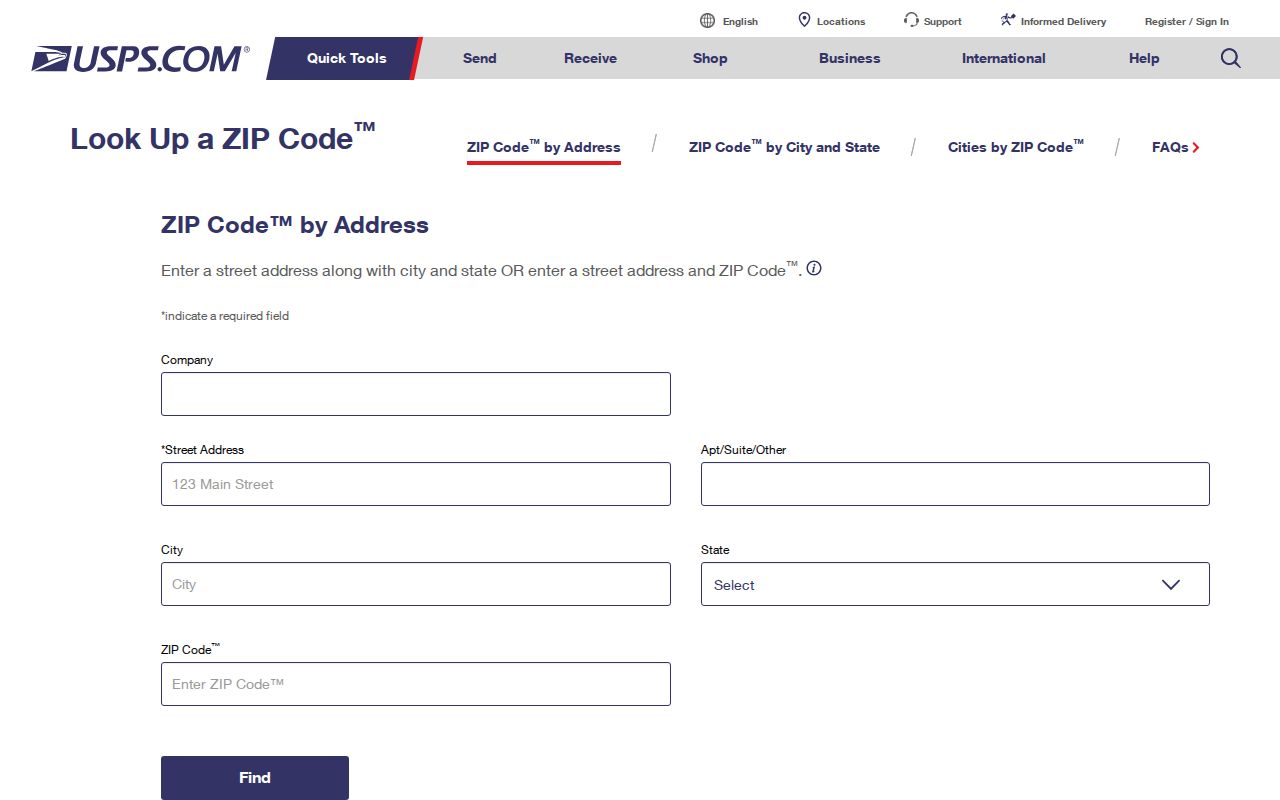
Its address-first approach is important because the township has no unique ZIP and a ZIP-only search can pull in adjoining jurisdictions.
Search a Blackman Township ZIP Code
A ZIP can narrow address work, but the documented Blackman property tools do not make it a substitute for a jurisdiction check. Blackman BS&A Online has Address, Name, and Parcel Number search modes. The Parcel Viewer supports searching, zooming, and selecting a parcel. Use a ZIP result to organize a group of addresses, then check each address or parcel individually. The utility-billing path is for account and payment administration, not proof that a person lives at an address.
- Validate the full address through USPS and record its ZIP and postal city.
- Enter the address in Blackman BS&A or locate it in the Parcel Viewer.
- Save the situs address, parcel identifier, legal-description clue, and assessment-year context.
- Confirm the municipality before using a parcel name as a lead for another official record.
Michigan’s public voter service is for registration-status checking, not a ZIP-based public roster. A QVF request can be scoped by jurisdiction and precinct, but that form does not make a ZIP result a replacement for election geography. For a full street-level chain after the parcel check, use the Blackman Township street directory.
Blackman Township ZIP Code Identifiers
One address can have several valid identifiers. Jackson County GIS assigns a parcel and municipal context. Election administration uses a jurisdiction and precinct. USPS assigns a postal city and ZIP. Census reporting uses statistical geography. Combining those values into one unnamed number creates false matches, especially where a Jackson postal label crosses the Blackman Township line.
| Identifier | Responsible system | What it answers |
|---|---|---|
| Parcel identifier | Jackson County GIS and Equalization | The mapped parcel and municipal record. |
| ZIP and postal city | USPS | How mail is addressed and routed. |
| Precinct | Election authorities | Election administration geography. |
| Census FIPS | U.S. Census Bureau | Statistical geography, not a parcel key. |
This is a useful confidence check. A current parcel display is assessment and mapping context. A postal ZIP is delivery context. Neither establishes the facts found in a recorded deed, a protected voter file, or a historical directory scan. Save the source date beside each value so an old result is not mistaken for a current one.
Note: Preserve the postal ZIP, parcel number, precinct, and Census identifier separately when comparing Blackman Township sources.
Blackman Township ZIP Code Search Fields
Search fields vary by system, so copy an address in the format each portal requests. The township property search documents Address, Name, and Parcel Number modes. CountyFusion, the Register of Deeds portal, uses a 15-digit county parcel number without dashes, while the county viewer can display a dashed form. This small format difference matters when a ZIP search leads to a parcel that needs a deed history.
| Portal | Field or control | Format or use |
|---|---|---|
| Blackman BS&A | Address | Start with the validated address. |
| Blackman BS&A | Name or Parcel Number | Alternative documented modes for confirmation. |
| County Parcel Viewer | Search, zoom, or click parcel | Map route to parcel and assessment context. |
| CountyFusion | Parcel ID | Use 15 digits without dashes; not all deeds contain one. |
Leave the deed-name field blank when searching CountyFusion by parcel ID, as the Register instructions direct. If that search fails, switch to the grantor or grantee name and legal description. A person’s name or a ZIP alone is too weak for a reliable historical property match.
Blackman Township ZIP Code Boundary Limits
ZIP boundaries are delivery areas, not city or township limits. The Michigan Department of Technology, Management and Budget publishes an official Michigan ZIP map, but it is statewide and cannot validate a particular street. 49202 is reported to reach nearby jurisdictions. A returned 49201 or 49203 likewise needs an address-level check, not a broad municipal assumption.
- ZIP code
- A Postal Service delivery-area identifier. It does not describe a township boundary.
- ZIP+4
- An added delivery segment that refines routing for a specific address or delivery point.
- PO Box ZIP
- A post-office-box ZIP that can differ from a street-delivery ZIP.
- Carrier route
- A delivery grouping that does not establish parcel jurisdiction or occupancy.
No unique Blackman-only ZIP or official township post office was located. A post-office-box ZIP should not be used to infer a home location. For an existing addressing record or map, request the actual record through the Blackman Township FOIA channel rather than asking a custodian to create a ZIP directory.
Blackman Township ZIP Code History Gaps
No authoritative Blackman-specific table of historical ZIP changes or rural-route conversions was located. Older letters, directories, and deeds can use postal descriptions that do not line up with a current address. Treat the old ZIP or route as a lead, then pair it with a legal description, section, lot, subdivision, owner name, and nearby road from the relevant period.
A historical directory or atlas can connect an address to a period, yet it may not show the current municipal line. Jackson collections sometimes reach township edges, but every edition’s scope must be checked. The absence of a name in one postal area is not proof that the person, parcel, or historical route did not exist.
For a current address that seems to have an older number or route, compare the township and county address records with the parcel’s legal description. Jackson County GIS maintains address and street-centerline information for county functions, while the township’s zoning and addressing materials are the local administrative route. If an existing address application, map, or address record is needed, request that identified record by address, parcel, and date range. Do not ask either custodian to create a historical list of people by ZIP.
Note: When historical and current ZIP descriptions differ, use the parcel and legal description as the bridge instead of guessing a modern equivalent.